HIKING IN BLUE RIDGE MOUNTAINS | ACTIVITIES IN THE NORTH GEORGIA | OCOEE RIVER AREA
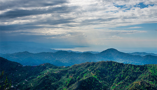
ONE OF THE MOST POPULAR ACTIVITIES IN THE NORTH GEORGIA AREA IS HIKING IN BLUE RIDGE. JUST A SHORT DRIVE FROM OUR BLUE RIDGE CABIN RENTALS. ALSO, YOU’LL FIND MILES AND MILES OF HIKING TRAILS THAT MEANDER THROUGH THE NORTH GEORGIA REGION – SOME OF THE MOST BEAUTIFUL WILDERNESS IN THE COUNTRY. WE’VE PUT TOGETHER SOME OF OUR FAVORITE TRAILS TO GET YOU STARTED. FROM QUICK, FAMILY-FRIENDLY HIKES ALONG BABBLING CREEKS TO MORE ADVANCED HIKES WITH STUNNING VIEWS OF THE BLUE RIDGE PEAKS AND THE TOCCOA RIVER . LIKEWISE THERE’S SOMETHING FOR EVERYONE WHEN HIKING IN BLUE RIDGE MOUNTAINS..
ONE OF OUR FAVORITE ACTIVITIES THAT GUESTS LOVE IS DAFFODIL FARM AND CARRIAGE RIDES. GREAT VENUE AND SUPER NICE FOLKS THERE. SUPER ALTERNATIVE TO HIKING! VISIT OUR BLOG
ASKA TRAIL SYSTEM
The Aska trail area includes a 17-mile hiking/mountain biking trail system in the National Forest close to some of our mountain cabin rentals. The trails are accessed off of Aska Road with parking near Deep Gap in Blue Ridge. The trails range from 1 to 5.5 miles and offer a range of difficulty. Here are some initial details on some of the trails:
1- Deer Gap Trail: located off of Aska Road- advanced hiking trail and/or single track mountain biking trail.
2-Flat Creek Trail: 4-mile hiking trail (the loop is 5.9-mile single-track trail); approximately 1.5 hours over creek crossings and rocks with magnificent vistas.
3- Green Mountain Trail: 4.6 mile easy to moderate hiking trail; leaves from Deep Gap in the Aska Adventure area and takes approximately 2 hours; Offers views overlooking Lake Blue Ridge.
4- Lake Blue Ridge Trail: 0.6-mile easy hiking trail; Flat trail that follows the lake’s shoreline and is ideal for families with children.
5- Long Branch Trail: 2.3-mile easy hiking trail loop with a double track for mountain bikers; Approximately 0.5 hours over an old roadbed with a creek crossing and excellent views.
6-Stanley Gap Trail: 4.6 miles moderate to difficult steep hiking trail with access off of Stanley Creek Road; Approximately 1.5 hours with a 3,365 elevation; Recommended to leave a second car at the end of the trail.
7- Stanley Creek Loop: 1.4 miles easy, gravel Forest service’s road with the single track; Approximately 1 hour; Takes you along Stanley Creek.
8- Water Falls off of Stanley Creek Road: a 20-minute hike up to the falls with moderate elevation change makes this a great walk for people across all skill levels.
9- Rich Mountain Wilderness Preserve: Experienced hike where it is suggested that hikers carry topographical maps, compass and survival gear. This area has a large bear population; Trail crosses several streams and also along waterfalls.
COHUTTA NATIONAL FOREST DISTRICT TRAILS
he Cohutta National Forest District trail area includes over 95 miles of hiking trails within Georgia and Tennessee. If interested in hiking these trails, we recommend for you to get a map. Then check river and weather conditions from the US Forest Service. Meanwhile, see below for some details on a few of the Cohutta trails:
● South Fork Trail & Loop: 3 miles moderate, US Forest Service hiking and mountain biking trail. Approximately 1.5 hours across an old logging roadbed. For the loop, add about 1.5 hours to traverse another 5.2 miles on a gravel forest road alongside a waterfall
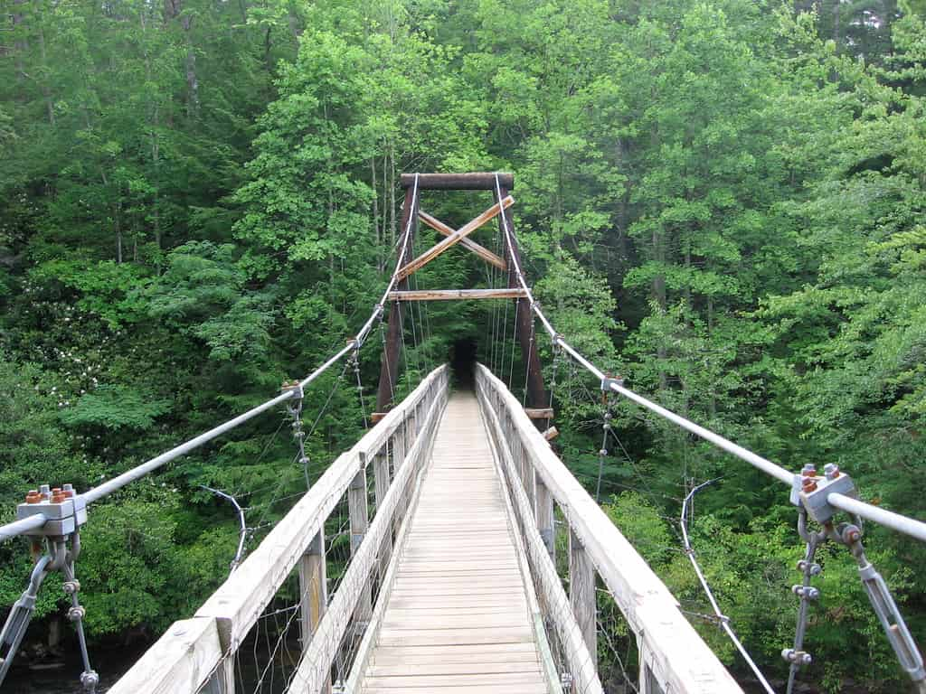
● Benton MacKaye Trail: a 78.6-mile trail that can be subdivided into day hikes. It is also suitable for hiking and some mountain biking. One section of the trail takes you across the Swinging Bridge, the longest suspension bridge east of the Mississippi. One of the most popular hiking trails in the area. This stretches from Springer Mountain to Double Spring Gap on the Tennessee border. The first 20 miles of this trail merge with the Appalachian Duncan Ridge Trails.
●Panther Creek Trail: 3.4 miles, moderately tricky to a strenuous hiking trail with some rocky sections. It is both popular and scenic; Highlights include a high waterfall.
● Beech Bottom Trail: 4.0 mile, accessible to a moderately steep hiking trail.
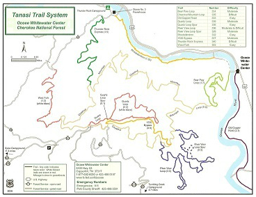
TANASI TRAIL SYSTEM
Boasting more than 20 miles of trails, the Tanasi Trail System has it all. From a hike with history along the 2.4 mile restored segment of the Old Copper Road Trail. You can also take an easy 1 mile stroll around the Olympic course at the Whitewater Center. This leads to a screaming 1.5 mile mountain bike ride on the Thunder Rock Express. Mountain bikers and hikers alike will be challenged and rewarded when they reach the top of Bear Paw Loop. Then travel Chestnut Mountain Trail to sites that overlook the Whitewater Center and the Ocoee River
—
Get additional trail information from the Blue Ridge, Georgia Chamber of Commerce.